HONEYBEEDRONE SERVICES

BASED IN OHIO. AVAILABLE NATIONWIDE.

Drone inspections,
mapping, and
progress photography.

See the whole site in greater detail. Custom drone photography and thermal imaging for infrastructure, energy, and construction projects.

SITE OVERVIEWS AND CLOSE-UP PHOTOS
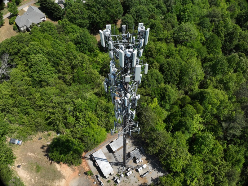
Aerial overview of a communications tower rising above green woodland
+
COMMUNICATIONS TOWER
INFRASTRUCTURE+RENEWABLE ENERGY+CONSTRUCTION

Drone services.

Choose close-up inspections, site mapping, or scheduled progress photography. We plan the flight around the areas you need photographed.

INFRASTRUCTURE

Tower, roof, and
utility inspections.

Detailed photos of antennas, mounts, cables, roofs, and utility equipment help your team review areas that are difficult to reach.

  • Site overviews and close-up photos
  • Photos organized by area or component
  • Photo labels and annotations as agreed in your quote
Request a quote ↗
MAPPING & 3D

Aerial maps and
3D models.

Combine overlapping drone photos into a map or 3D model to show the site’s layout, buildings, and equipment.

  • Site maps made from drone photos
  • 3D models for viewing site features
  • Files for project planning and presentations
Request a quote ↗
RENEWABLE ENERGY

Solar and wind
inspections.

Color photos and thermal imaging help document energy equipment for maintenance, installation checks, and damage review.

  • Color photos and thermal images
  • Installation progress photos
  • Scheduled inspections and emergency callouts
Request a quote ↗
CONSTRUCTION

Construction
progress photography.

Show what has changed between site visits with dated aerial photos taken from consistent viewpoints.

  • Dated site photos
  • One-time or scheduled visits
  • Photos for project reports and presentations
Request a quote ↗

Read about mapping and inspection limits.

Sample drone photos.

Explore close-up and overhead photos of towers, rooftops, solar installations, and utility equipment. Select a photo to enlarge it.

TOWER / COMPONENT DETAIL

Tower components, up close.

Detailed photos of antenna panels, mounts, and cable connections.

SOLAR / COLOR PHOTO EXAMPLE

Rooftop solar inspections.

Thermal imaging and color photos of roofs, solar panels, and mounting hardware.

ROOFTOP EQUIPMENT

Rooftop equipment inspections.

Inspect rooftop equipment without sending a person onto the roof.

INSTALLATION / SITE RECORD

Installation progress.

Document completed work and changes between site visits.

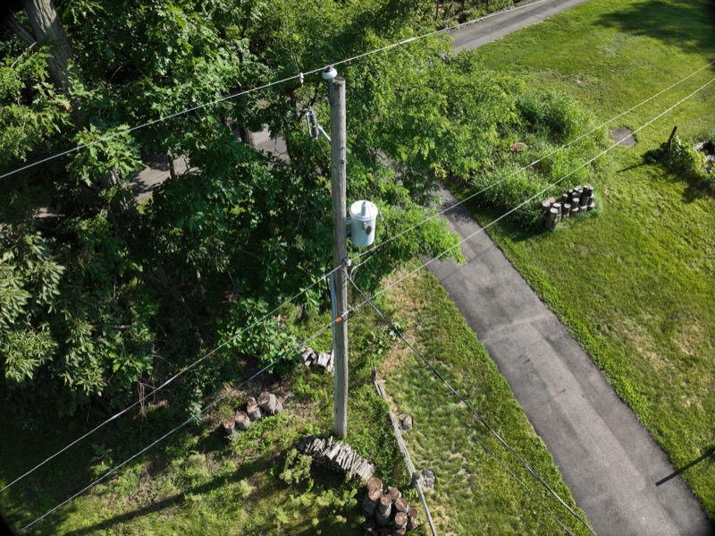
UTILITY / VISIBLE COMPONENTS

Utility pole inspections.

Close-up photos of transformers, connections, and overhead equipment.

ENERGY / EMERGENCY RESPONSE

Energy inspections and emergency response.

Available for urgent inspections and extended assignments. Contact us to discuss timing and location.

Elevated view of a utility pole, transformer, and connected lines beside trees

How booking works.

  1. Tell us what you need

    Share the location, the areas you need photographed, and your preferred dates.

  2. Plan and complete the flight

    We confirm access, flight requirements, and the photo coverage before the visit.

  3. Receive your files

    Receive the photos, thermal images, maps, or models listed in your quote, organized for your team to use.

About Honeybee
Drone Services.

Honeybee Drone Services is based in Ohio and provides drone photography, thermal imaging, and site mapping.

Book a single visit or arrange repeat flights. Your quote will list the work, location, schedule, and files included.

Request a quote ↗

Request a quote.

Tell us the project location, what you need photographed, and when you need it.

A general location and a few details are enough to start. Please leave out confidential site information.

This form prepares an email draft. Review it and press Send in your email app to submit your request.

Your details are used to respond to your inquiry. This page does not store form entries or use analytics cookies. Privacy details

FREQUENTLY ASKED QUESTIONS

What will I receive?

Your quote will list the files included, such as color photos, thermal images, a site map, or a 3D model. We confirm the areas to cover and file formats before the flight.

What information helps with a quote?

Send the project location, the areas you need photographed, and your preferred dates. Tell us if you need thermal imaging, mapping, or repeat visits.

Can you document the site regularly?

Yes. We can arrange repeat visits and photograph the site from consistent viewpoints so your team can compare progress over time. Flight dates depend on weather, access, and flight requirements.

Do you provide land surveys or engineering assessments?

No. We provide photos, maps, and models for viewing site features. We do not provide boundary or topographic surveys, certified measurement accuracy, elevation data, material volume or earthwork calculations, engineering assessments, or structural or safety certifications.

Do you offer thermal inspections?

We offer thermal imaging and color photography (RGB) for roofs, solar installations, and other energy equipment.

What happens when I complete the form?

The form prepares an email draft addressed to Honeybee. Review and send it from your email app. We use the information you send to respond to your request. Please avoid confidential information.